Blog

  • Cascadia Community College

    Center for Global Learning and the Arts
    Cascadia Community College, Bothell, WA, USA
    Gustafson Guthrie Nichol Ltd (Landscape Architect) and Miller Hull (Architect)
    2009

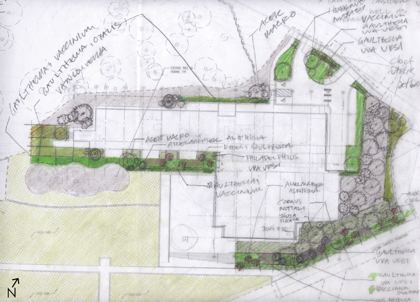
    This 2.5 acre native restoration of a steep site creates a new campus ‘heart’ between the existing CCC buildings and their new theatre and arts building. The design includes a 7000sf plaza, eco-turf Campus Green, monumental stairs, and a series of seat walls that provide multifunctional places for a wide range of informal and formal events for students, faculty, and the wider community. Based on a series of topographical moves that slice, stack, and retain the landform through an 11’ grade change, this minimalist design focused limited resources on tree protection, pedestrian infrastructure, soil reuse and improvement, and native, low maintenance plant material and seed mixes. (Melissa Cate Christ: Project manager & designer – SD-CA)
    Cascadia Community CollegeCascadia Community College
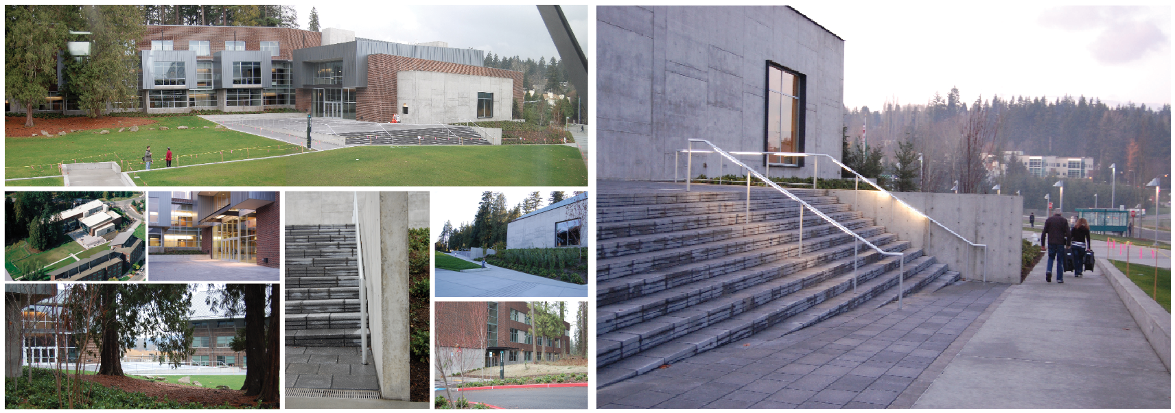
    Top, clockwise from top left: plaza, stairs and path create a new campus heart and circulation system; concrete paver stairs and lit handrails; west entry, embedded in forested slope; north entry from existing promenade; ‘stacked’ stairs, handrail, and north plaza wall; view of plaza from south exit through preserved stand of Pseudotsuga menziesii and Thuja plicata; east entrance with seat wall; construction aerial photo, Sept. ‘09. From bottom left: student welcoming event on the Plaza, October 2010; native forest hydroseed mix, 1 gal. Salal and 4” pots Vancouveria hexandra & Oxalis oregona – Year 1; N/S campus path; Bike parking and native planting at west entry; students hanging out on campus.
    Cascadia Community College
    Above: Planting design sketch – northwest native
    seed mixes and semi-formal plantings to restore the 2nd growth forest ecosystem.

  • CityCenterDC

    CityCenterDC
    Washington DC, USA
    Gustafson Guthrie Nichol Ltd and Jeff Lee & Associates (Landscape Architects),
    Foster and Partners and Shalom Baranes Associates (Architects) and Clark Construction.
    CityCenterDC press.
    2014 (construction completed)

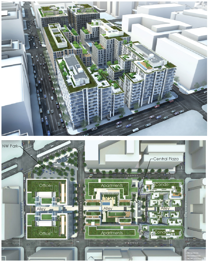
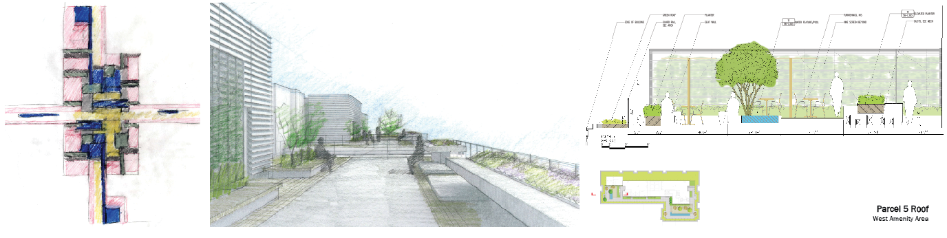
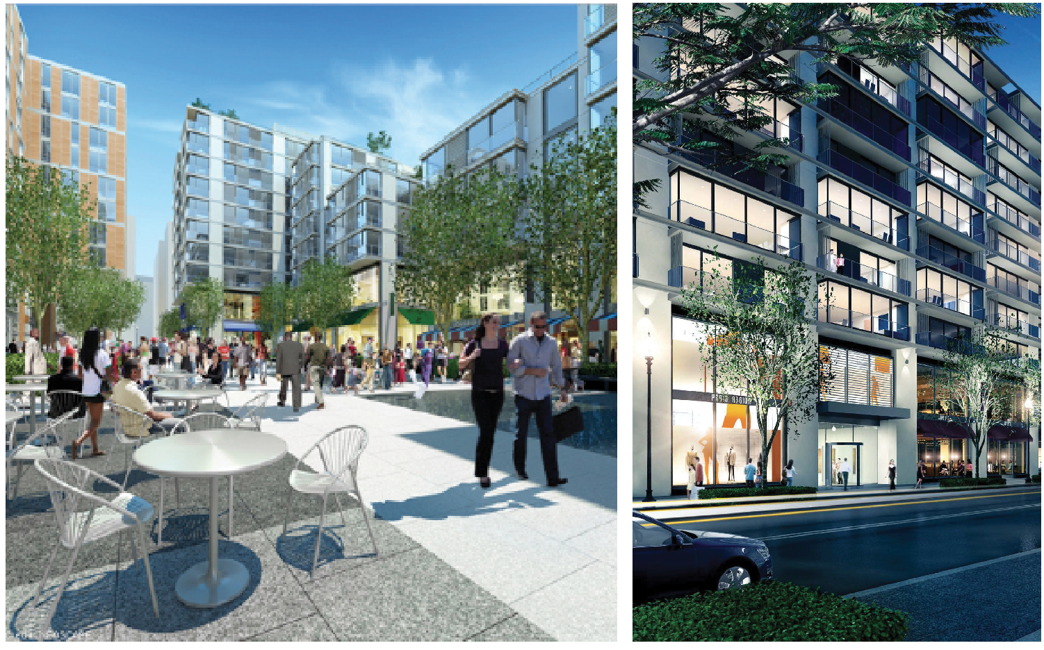
    Located on the 10 acre superblock of the old Washington Convention Center, this vibrant mixed-use development provides the neighborhood with a network of public open spaces, fine scale retail, restaurants, and local services, as well as new offices, apartments, and condos. The new buildings are outfitted with roof terraces that include wood decks, pools, and gathering spaces in addition to intensive and extensive green roof planting strategies.The project has been certified LEED ND Gold.
    CityCenterDCTop: bird’s eye view looking NW. Bottom: plan view. Image credits: Neoscape.

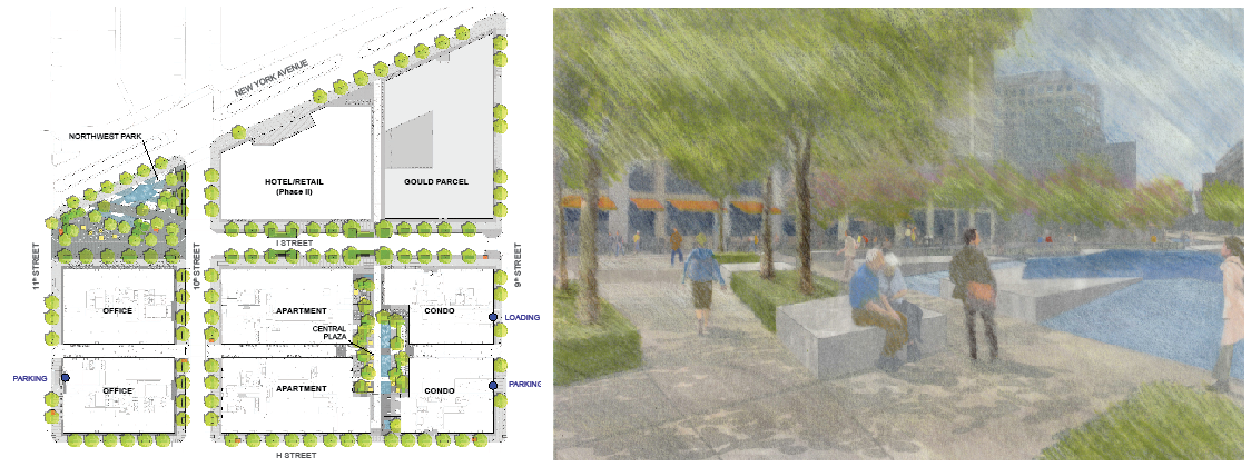
    The re-introduction of the street grid incorporates innovative “green streets” that capture and bio-filter sidewalk and street stormwater, as well as a pedestrian alley that creates an intimate urban experience rare amidst DC’s wide streets. Evoking the source and path of a long-buried tributary of Tiber Creek, as well as L’Enfant’s vision for a fountain in the pair of ‘bow-tie’ parks at the NW corner of the site, the movement of water defines the new park and plaza. Emerging as a monumental fountain, bubbling basin or playful jet and flowing over textured surfaces or shimmering like glass in quiet scrims, the water features employ sustainable practices for multi-seasonal effects. The open spaces and streetscapes are formed by a mix of evergreen and deciduous plants, a significant number of new trees, public and restaurant seating and flexible spaces for events and recreational activities. (Melissa Cate Christ: Project manager and designer, Master Plan – 100% CDs)
    CityCenterDCCityCenterDCCityCenterDC
    Clockwise from top left (all image credits GGN unless noted): site plan; looking SW across NW Park (SD rendering); Condo upper roof section showing outdoor kitchen, raised deck, water feature, seating, and hidden duct runs (DD rendering); looking NE across Central Plaza; looking SW across I Street at Condos (Both image credits: Neoscape); Central Plaza quilt/weave concept & program sketch; looking north across Office roofs at planted screen, wood seating and sedum “bar” & seating (DD rendering).

  • we’re open!

    We’re Open!
    Merge Studio Lab’s Water Tower Project/PDX
    2011

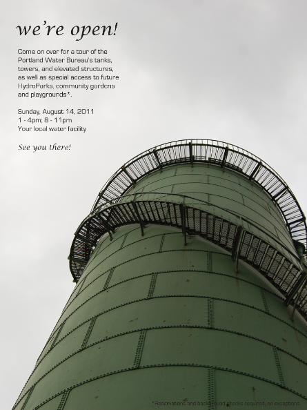
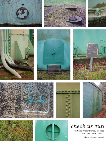
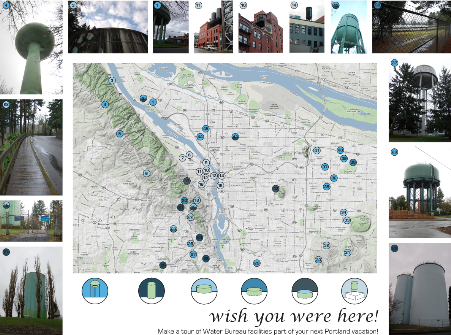
    Although an effort has been made in recent years to open the grounds of Portland’s Water Bureau properties through the creation of HydroParks, the majority are fenced off, and none allow access to the tanks/towers themselves. This project acknowledges the tension between public and private and posits that through public access to Water Bureau Facilities, they can become integral to the neighborhoods in which they are located, as well as become city-wide attractions, providing much-needed open space and much-desired expansive views of the city.

    we're open!

    we're open!

    we're open!

  • dinner for 8 or to each their own

    dinner for eight or to each their own
    The Art of Urban Environments Festival, Easton, PA
    Finalist
    2011

    As a recovering post-industrial city with a rich history and a vibrant arts and cultural scene, Easton’s development of the Karl Steiner Arts Trail is an exciting step towards expanding and diversifying its pedestrian experience. A fertile ground for intervention, the trail’s adjacency and connection to sites of historical, cultural, and functional interest suggests possibilities for viewer discovery, interpretation, and engagement.

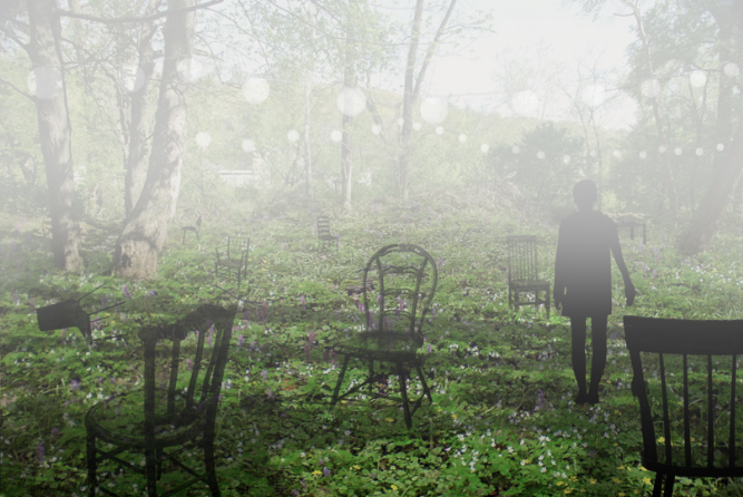
    Located along the trail at the Bend of the Bushkill, the forest clearing symbolizes both the wonder of nature and the agency of humans. Seen as a refuge from the wilderness or a flower filled sanctuary mysteriously untouched by human hands, the clearing is the historical gathering place of nymphs, pleasure parties, and solitary travelers. This conception of the clearing is set against the actual regenerative cycle of the forest – gaps are created and filled in an eternal process that can be slowed or stopped only by human intervention, often to perpetuate a memorable natural condition or to exploit the resources of the forest itself. It is this tension between the cycles of reality and memory, party and after-party, nature and culture, which forms the foundation for the proposed installation, dinner for eight or to each their own.

    Initial installation, Spring
    dinner for 8 or to each their own
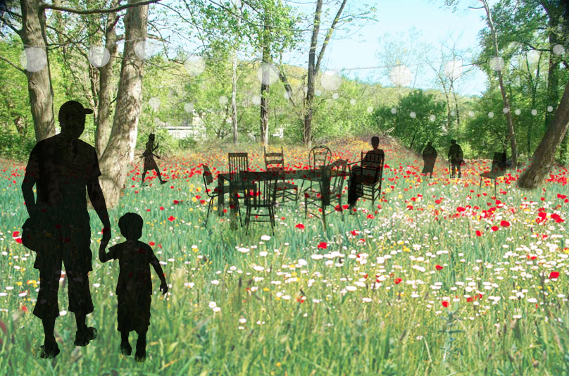
    Summer
    dinner for 8 or to each their own
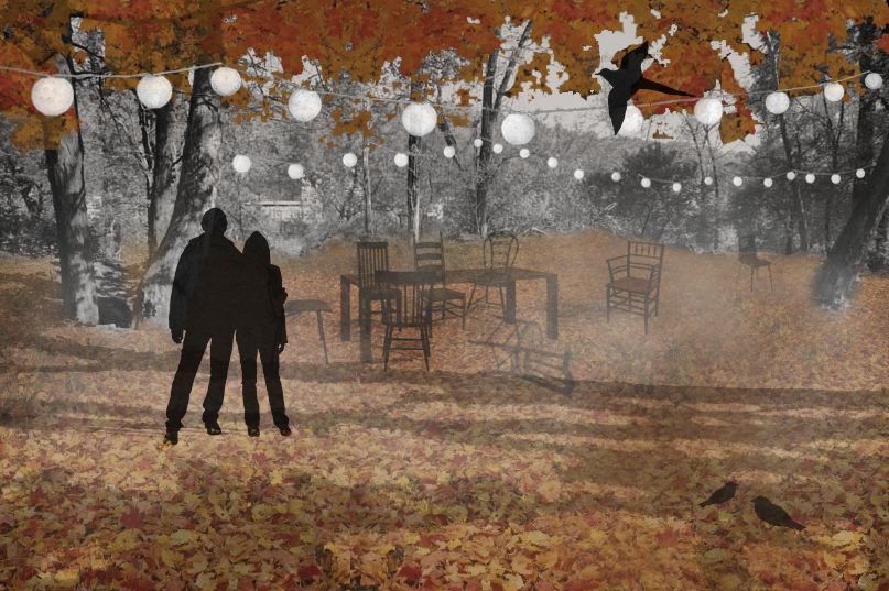
    Fall
    dinner for 8 or to each their own
    Separated from it’s historical adjacency to the Easton cemetery by U.S. Route 22, dinner for eight or to each their own explores the interaction of history, memory, and culture in the evolution of the natural environment, as well as the role of viewer discovery along the spectrum of hushed audience to active participant. Composed of a mismatched dining set collected from local consignment and antique stores to personify each period of Easton’s history, the installation begins in the spring as an abandoned site of a dinner party, presumably hastily vacated after a sumptuous feast and raucous crowd. Seeded with native successional groundcovers, grasses, and understory plants, the site will be progressively enveloped in vegetation as the seasons pass.

    Throughout the Festival, viewers are invited to be participants – to rearrange the furniture, to have their own picnic or dinner party, to simply be a part of the scene as they find it – therefore altering the trajectory of the installation and composing a new history for the objects, the planting, and the site itself. These transformations will be archived by the uploaded photo-documentation of visitors themselves – whether of neglected and weathered antiques that evoke the souls buried nearby or of an actively and regularly visited place. The installation is open ended, an evolving and changing experience which may or may not be visibly altered upon successive visits, but
    which will capture the imagination and inspire moments of inquiry, contemplation, and discovery.

  • growing gowanus

    growing gowanus
    transverse studio with Patrick Keegan
    Gowanus Lowlands ideas competition
    2011

    Selected entry – Gowanus Lowline Exhibition: Connections
    SET Gallery, Brooklyn
    Sept 15 – Oct 1, 2011
    See here for the online exhibition of all the winning and selected entries.

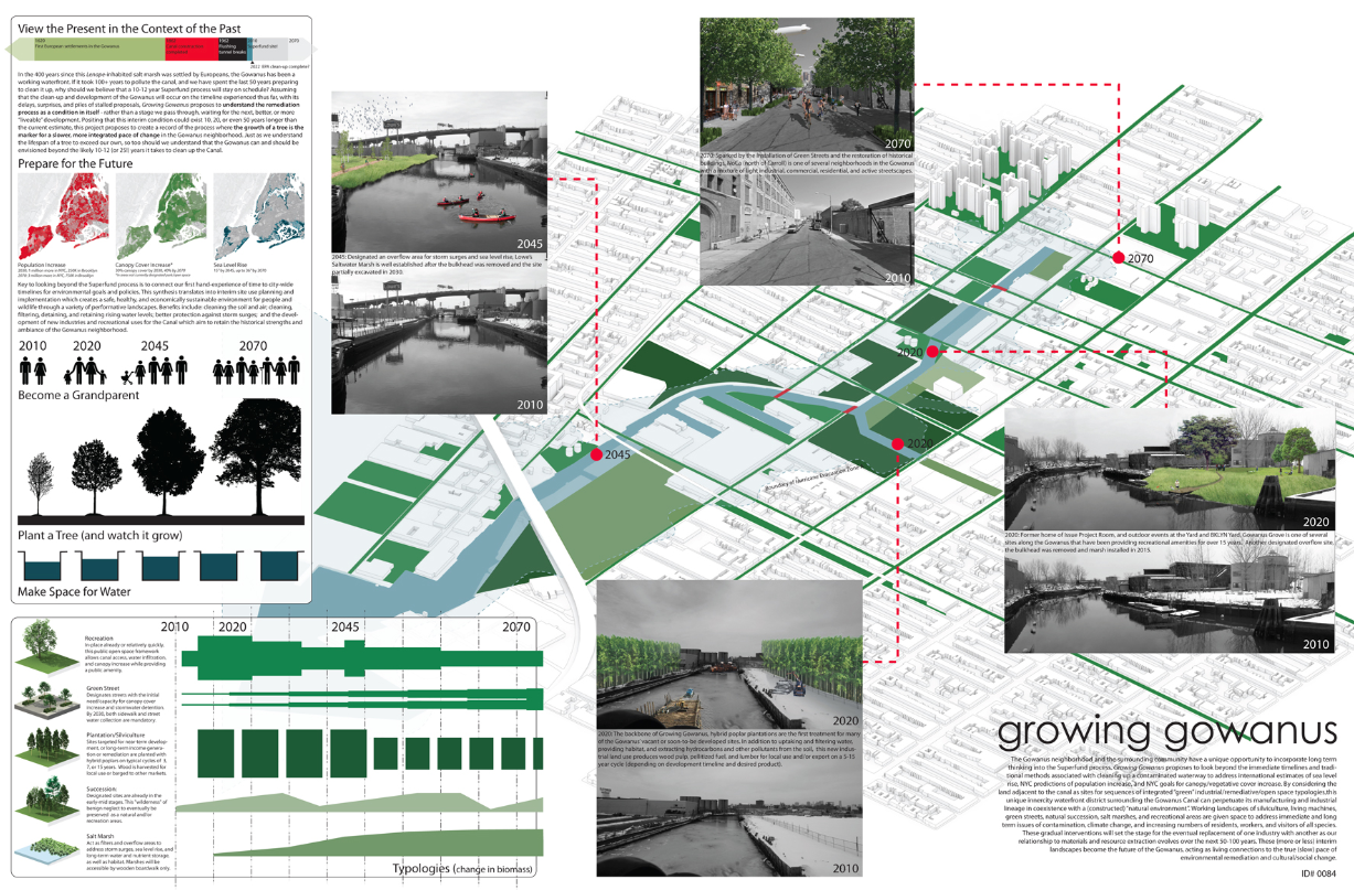
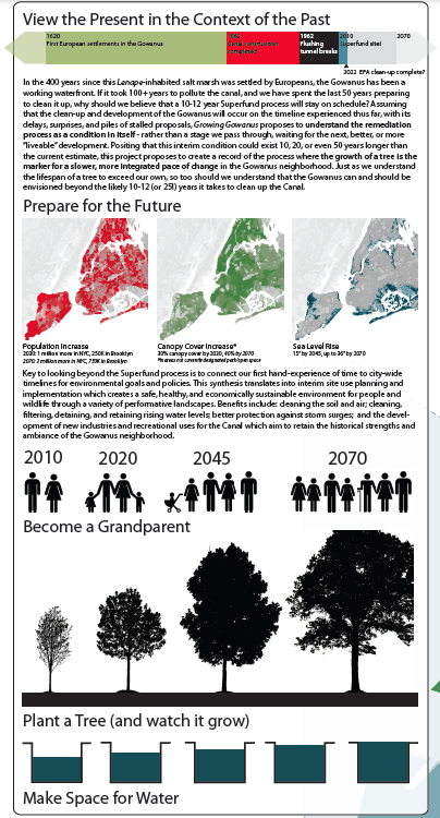
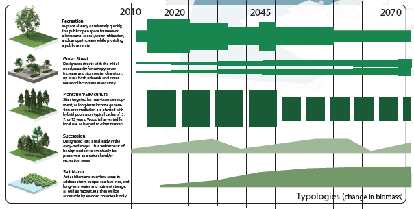
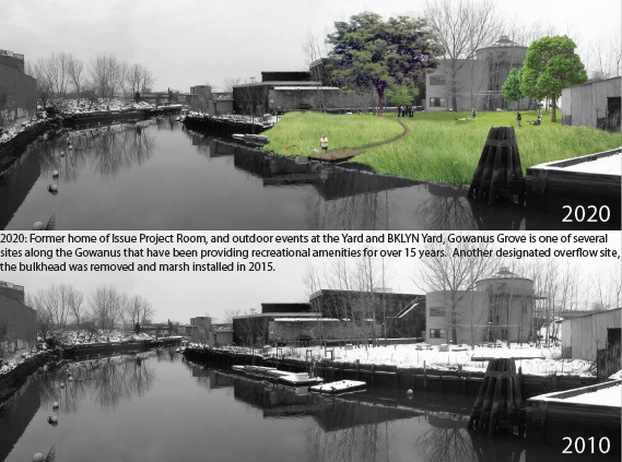
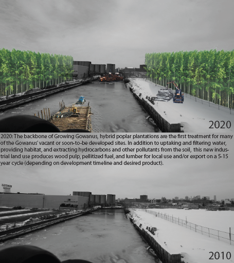
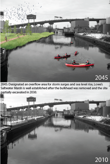
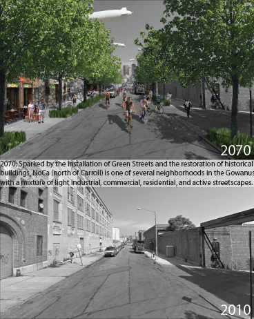
    The Gowanus neighborhood and the surrounding community have a unique opportunity to incorporate long term thinking into the Superfund process. Growing Gowanus proposes to look beyond the immediate timelines and traditional methods associated with cleaning up a contaminated waterway to address international estimates of sea level rise, NYC predictions of population increase, and NYC goals for canopy/vegetative cover increase. By considering the land adjacent to the canal as sites for sequences of integrated “green” industrial/remediative /open space typologies, this unique inner city waterfront district surrounding the Gowanus Canal can perpetuate its manufacturing and industrial lineage in coexistence with a (constructed) “natural environment”. Working landscapes of silviculture, living machines, green streets, natural succession, salt marshes, and recreational areas are given space to address immediate and long term issues of contamination, climate change, and increasing numbers of residents, workers, and visitors of all species. These gradual interventions will set the stage for the eventual replacement of one industry with another as our relationship to materials and resource extraction evolves over the next 50-100 years. These (more or less) interim landscapes become the future of the Gowanus, acting as living connections to the true (slow) pace of environmental remediation and cultural/social change.growing gowanus
    In the 400 years since this Lenape-inhabited salt marsh was settled by Europeans, the Gowanus has been a working waterfront. If it took 100+ years to pollute the canal, and we have spent the last 50 years preparing to clean it up, why should we believe that a 10-12 year Superfund process will stay on schedule? Assuming that the clean-up and development of the Gowanus will occur on the timeline experienced thus far, with its delays, surprises, and piles of stalled proposals, Growing Gowanus proposes to understand the remediation process as a condition in itself – rather than a stage we pass through, waiting for the next, better, or more “liveable” development. Positing that this interim condition could exist 10, 20, or even 50 years longer than the current estimate, this project proposes to create a record of the process where the growth of a tree is the marker for a slower, more integrated pace of change in the Gowanus neighborhood. Just as we understand the lifespan of a tree to exceed our own, so too should we understand that the Gowanus can and should be envisioned beyond the likely 10-12 (or 25!) years it takes to clean up the Canal. Key to looking beyond the Superfund process is to connect our first hand-experience of time to city-wide timelines for environmental goals and policies. This synthesis translates into interim site use planning and implementation which creates a safe, healthy, and economically sustainable environment for people and wildlife through a variety of performative landscapes. Benfits include: cleaning the soil and air; cleaning,altering, detaining, and retaining rising water levels; better protection against storm surges; and the development of new industries and recreational uses for the Canal which aim to retain the historical strengths and ambiance of the Gowanus neighborhood.
    growing gowanus
    Vegetation Typologies: Recreation; Green Street; Plantation/Silviculture; Successional; Salt Marsh
    growing gowanus
    Visual timeline of vegetation typologies applied to the site


  • save our wading pool!

    Open our Wading Pool!
    2011
    With the support of the Leschi and Madrona community councils, and mom’s groups, the co-op at Central Community College, Seattle Parks and Rec, and numerous other community members and parents.
    save our wading pool!
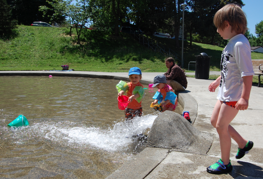
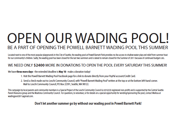
    Implemented in Spring/Summer 2011, “Open our Wading Pool!” is a community-sourced project to reopen the Powell Barnett Park wading pool, located in the Central District (CD) neighborhood of Seattle. Initiated by Melissa Cate Christ and executed in collaboration with a network of community groups and municipal departments, the project re-activated a public space whose operation had been abandoned due to budget cuts. Through a series of events, poster campaigns, and grassroots outreach activities, an incremental engagement and empowerment of the local community was enacted, allowing the temporary occupation of an often overlooked but crucial public amenity, the humble wading pool.
    save our wading pool!
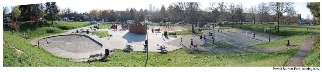
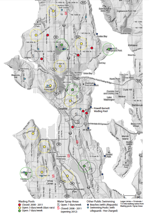
    Historically neglected, Powell Barnett (PB) Park was the site of a Starbucks-sponsored BOOM makeover in 2006 , transforming the 40 year old legacy of a community leader into a “destination park” which serves an ethnically and economically diverse range of Seattle residents and visitors. Despite the huge popularity of the park, the PB wading pool, a crucial summer component of a park/playground in full sun, was closed in 2009 and 2010 due to city budget cuts.
    save our wading pool!
    Led by Melissa, as both a landscape architect and a CD resident (with two toddlers), the project began as advocacy research into the neglected concrete basin in PB park. Over time, it became a grassroots, event-staging, outreach and fundraising effort which was able to successfully negotiate the opening of the PB wading pool on a weekly basis for the summer of 2011.

    Supported by local community groups, the project consisted of a poster campaign, followed by the establishment of an online presence through a Public Places Facebook page and on the local blogs the CD news and the Madrona neighborhood blog.

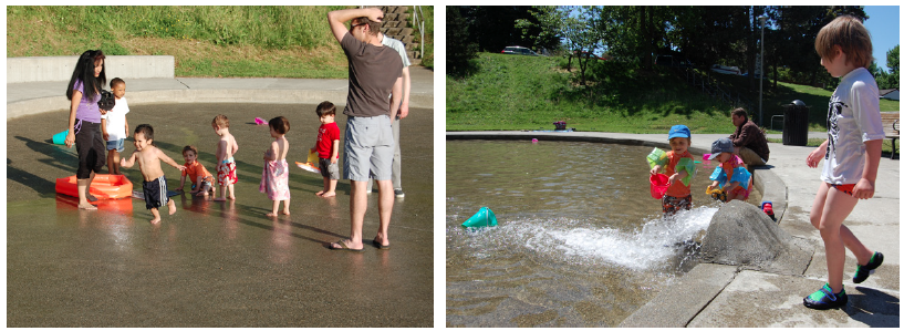
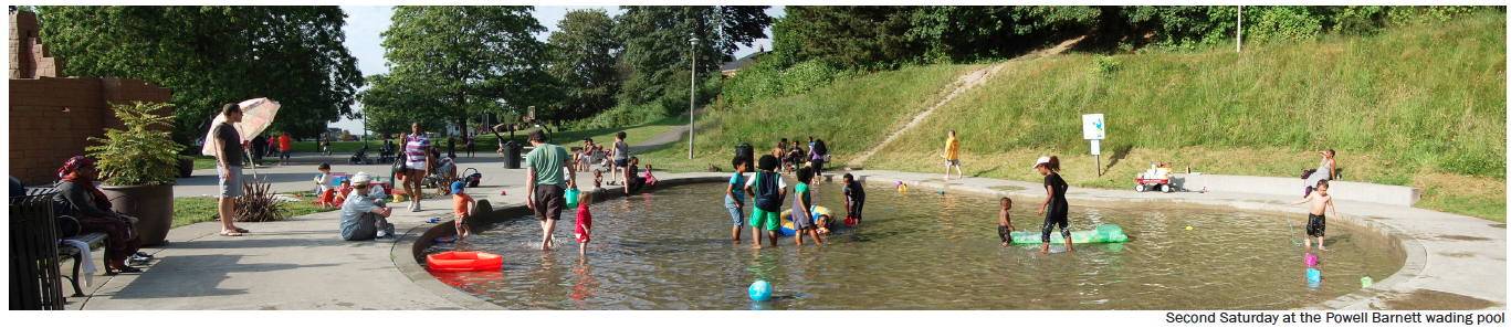
    The project staged a series of events: a “Wade-In” where we occupied the empty pool (the stars aligned for 65 and sunny in May – a near miracle in Seattle!) to raise awareness about the value of the currently squandered park space, and a fundraiser at a local pizza place (the owner’s son had splashed in the pool in previous years). In the end, eight Saturdays were funded through the raising of $4400 with over 60 donors, the majority of which were between $10-$50. Each open day was an event in itself, with BBQ’s, pool toys, music and high attendance. Average numbers were recorded at 169/day, putting the PB Wading Pool in the top five for average daily attendance. Due to a cool summer, the season was extended by two weeks across Seattle, fulfilling Parks and Rec’s commitment to us to open the PB pool for eight days and a sign that the City has begun to understand the cultural value of these humble concrete basins.
    save our wading pool!save our wading pool!

    Spring 2012 update: On the heels of our success last summer, we plan to lobby for a more equitable distribution of city funding to spread the open days at pools across the city (rather than in 3 or 7 day clusters) so that the burden of private fundraising can be reduced/shared across the wading pool user base. Eventually, we want to see a shift away from building new spray parks and towards supporting and preserving the existing wading pools, many of which have been serving the community for 50+ years.
    save our wading pool!
    Summer 2012 update: Through a marketing campaign by ask.com, Powell Barnett Wading Pool was once again open Saturdays throughout the summer.
    Summer 2013 Update : Lacking a sustainable funding model, Powell Barnett Wading Pool did not open during the summer of 2013.
    Summer 2014 update: Seattle Parks and Recreation open a Facebook page just for Wading Pools and Spray parks!

  • Hong Kong Detail Catalogue

    Hong Kong Detail Catalogue
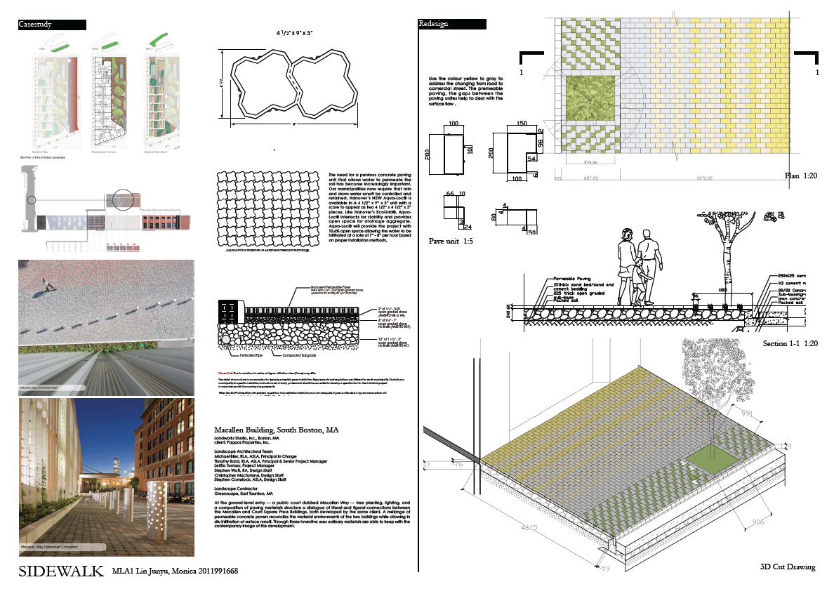
    MLA1 Spring 2012 ▪ ARCH 7105 Landscape Technology 2

    OVERVIEW
    As the second of two core landscape technology courses offered within the MLA curriculum, Landscape Technology 2 further investigates issues of site engineering, technology and construction, looking at typical and innovative landscape construction materials, methods and applications in the context of the urban environment. The course situates the built landscape, its cultural and environmental determinants and the resulting impacts of material extraction, sourcing, fabrication, installation, maintenance and disposal in relationship to the design and detailing of the urban landscape. The course readings and lectures are complemented by a multi-part research project which initially maps, catalogues, researches, and documents Hong Kong’s everyday public infrastructural details and assemblies.

    Term Project: HONG KONG DETAIL CATALOGUE
    With some of the densest urban areas in the world, Hong Kong has relied on the application of advanced landscape and infrastructure technology (eg land reclamation, detailed and exhaustive geological surveys, extensive public transportation investment) to further its geographical, topographical, and financial expansion. However, in the midst of billions of dollars spent on large scale infrastructural projects, many of the city’s public spaces are detailed, built, and maintained to a seemingly minimal standard. In this multi-part project, we will map, catalogue, research, and draw Hong Kong’s everyday public infrastructural details and assemblies. After the investigation of relevant case studies, each student will design and document a new detail assembly which improves both the functionality and aesthetic quality of a standard detail insertion and by extension, the entire network of infrastructural insertions. The project will be divided into four parts: 1) Typological documentation and mapping; 2) Detail construction research and drafting; 3) Case Studies/precedent research; 4) Design adaption and composite drawing. The four parts of the project will be compiled into a booklet to be submitted at the end of the term.

    The research and documentation from all of the students from the first part of the project is compiled on this open access Google Map.

    Please also see my article ‘Evidence of action: Towards an ecology of objects’, which places the student projects into a larger pedagogical framework.

    Typologies studied include:
    Curbs / Retaining walls/ Cut Slope stabilization / Fill Slope Stabilization / Handrails / Guardrails / Sidewalks / Benches /
    Stairs (at grade) / Drains / Water features / Tree pit/at grade planter / Planter (above grade) / Rubbish bin / Light standard (pole lighting) / In-grade/in-wall lighting / Bollards / Bike paths / Bus stops / Tram Stops / Ramp (intersection) / Crosswalk & pedestrian overpass / Pergola/trellis/canopy / Bike rack / Road signs

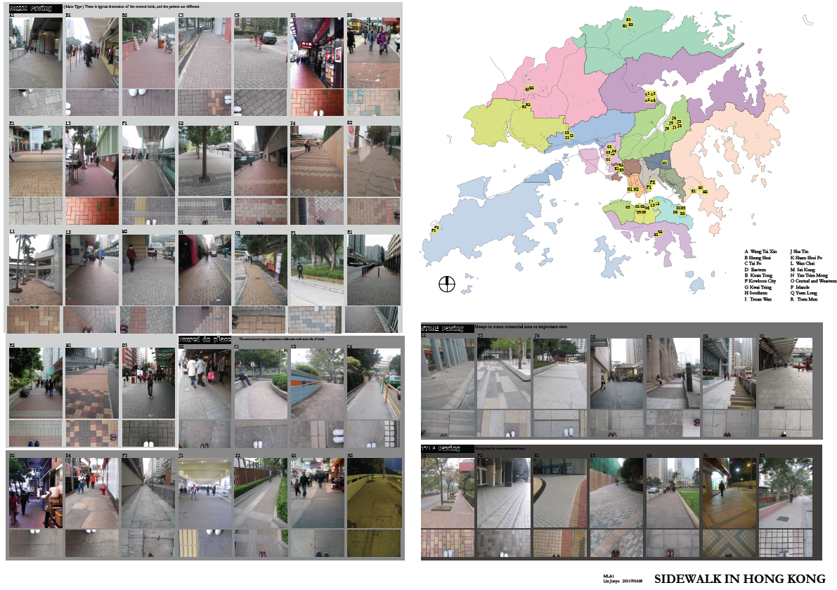
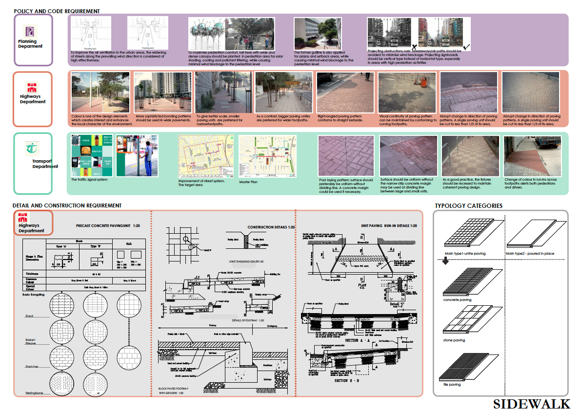
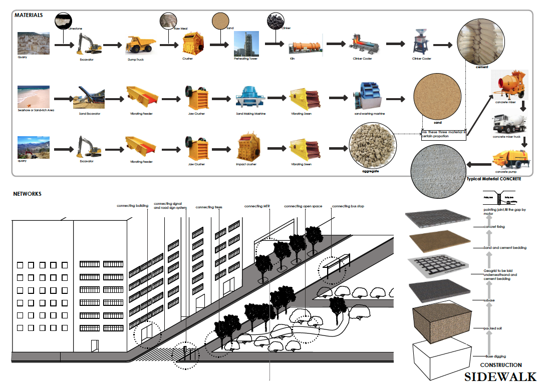
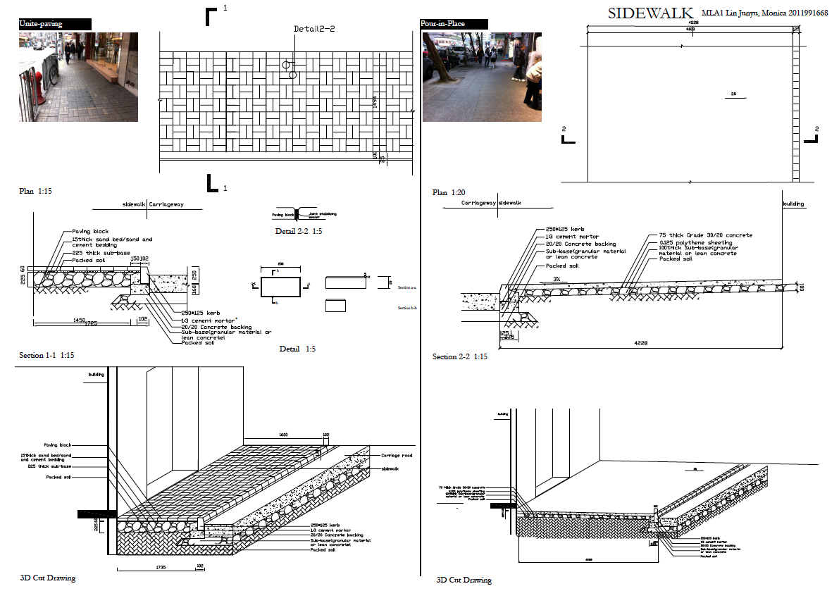
    The project below exemplifies the methodology and products of the term project (all image credits to Monica Lin)
    PART 1: Typological Documentation & Mapping( learning to see); PART 2: Typology Detail Construction Research (learning to research & represent) PART 3: Case Study/precedent & PART 4: Design adaption and composite drawing


  • environment community & design

    Environment Community and Design
    BALS3 2011-2013 – Arch 3029

    This course was an applied research seminar in the Bachelor of Landscape Studies program in the Division of Landscape Architecture, University of Hong Kong.
    environment community & design
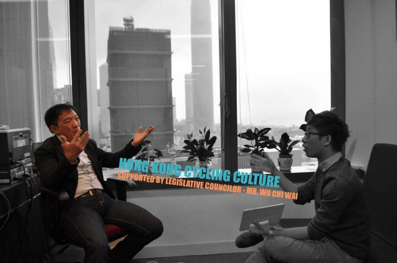
    Still from ‘Ride with me, Ride the Breeze’, a short documentary about the debate over a grassroots proposal to build a bike path along the northern edge of HK Island. The project was developed by 2012 ECD students Joshua LEUNG Lik Heng, Tamsin THORNBURROW, Yvonne MENG and Macy CHUNG Mei Sai.

    The course explores the complexity and interaction between urban environments and their communities, as well as the role of agency in design practice. It includes local and international research and case studies that demonstrate typologies of landscape formation, process and meaning. The course also includes a review of methods of community engagement, both formal and informal, as well as engaging students in ‘real world’ community issues , in particular the investigation of local community environments faced with the possibility major transformation through the development and construction of significant infrastructure.

    The primary focus of the engagement exercises of the 2011 iteration of the course was the escalator proposed for Pound Lane. The collected work can be found here. The projects and workshop were supported by the Faculty of Landscape Architecture and an HKU KE grant.

    The 2012 iteration of the course asked the students to investigate and engage in a contemporary issue in Hong Kong related to infrastructure development and its community impacts. The collected work of the course can be found here. The development of the framework of the course and the student projects were supported by an HKU Teaching Development Grant.

    The primary focus of the engagement exercises of the 2013 iteration of the course was the future of Pokfulam Village in the context of development pressures, heritage conservation and the lack of proper sanitary services in the village. The course worked in tandem with the student’s studio, also taught by Melissa Cate Christ (in collaboration with Seth Denizen). The collected work of both courses can be found at pokfulamvillage.com.

  • envisioning pokfulam village

    Envisioning Pokfulam Village
    Strategies of engagement and intervention in complex urban communities
    BALS2 Fall 2013 ▪ ARCH 2043 Landscape Design Studio II: Site and Community
    Instructors: Melissa Cate Christ and Seth Denizen

    The collected work of the studio, including documentation of the workshop executed as part of ARCH2041 Environment Community and Design, can be found at pokfulamvillage.com
    envisioning pokfulam village
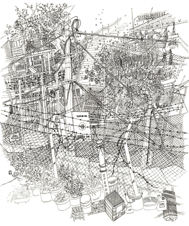
    Sun Chang Lo, Pokfulam Village, Hong Kong, 1996

    From the course syllabus & final project brief:
    This studio looks at the relationship between site and community by asking how landscapes and lives are assembled. How can the relationship between people’s lives and the infrastructure of living be addressed by landscape architecture? Further, and perhaps most fundamentally, the studio asks how a landscape can shape the way we live.

    Framed by these questions, the studio proposes to look at the assemblage of site and community relations in Pokfulam Village. In the original land allocation and layout of the village, each Hakka row house was allocated a plot of land to farm. As the population increased, many of the plots were leased and/or developed for non-formalized housing, leading a complex of different types of land tenure. In addition the 1982 Squatter Control Policy restricted the ability of residents to improve their homes, leading to the perception that the village is an urban slum due to its primary building material, metal sheeting, densely packed urban structure, and lack of basic sewage infrastructure. Ironically the Squatter Control Policy, combined with Pokfulam Road moratorium, has led to the preservation of the village, if only that it has not be redeveloped into high rise housing as much of the adjacent land has been. But with recent calls to lift the moratorium, community efforts to raise the profile of the village and to acknowledge its heritage value has led to it’s listing as a threatened site on the World Monuments Fund Watch list, raising the question of how to improve the living environment and accessibility of the village without losing its unque character and sense of community. In this context, the studio will explore the capacity and resilience of the village: what infrastructures, maintenance regimes and/or social practices can be embedded in the village and how would they be deployed and configured?

    In order to answer this question, the studio is composed of a series of cumulative exercises. The first studio exercise asks students to uncover an essential element of the village through their own observations – documenting a phenomena, element, process or idea in the form of a photo diary and short text. The second exercise examines the village’s current food supply and demand through the production of measured orthographic drawings of the village’s markets. The third exercise of the studio asks students to produced detailed maps of the ground materials and systems of the village, integrating the first two exercises and laying the foundation for the final design project. The final exercise of the studio asks students to layout a strategy and site design which addresses an issue or problem identified in their system/network mapping.

    Each exercise of the studio can be seen as a different way to explore the same fundamental questions: how landscapes and lives are assembled, how landscape shapes our lives, and how we shape the landscape. To that end, the studio exercises will be conducted in consultation with the local community through engagement exercises designed and executed by the students in the concurrent course, Environment Community and Design.

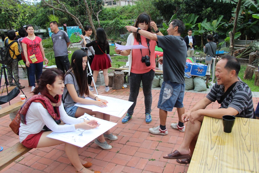
    Envisioning Pokfulam Village workshop, November 10, 2013
    envisioning pokfulam village
    How do we design in Pokfulam Village?
    The first step to answering the question of how to act is to define our role. Pokfulam is a city of designers. Almost everything in Pokfulam is hand-made, down to the pipes and infrastructure that form the most essential core of the urban environment. This throws our role into question: should we replace them as designers of their city? Are we better or worse designers than they are? How can we design from the top-down in a place that is built bottom-up?

    In order to formulate a coherent response to these questions we must think about the process of design as a partnership with the world, a process of becoming entangled in people’s problems and desires. In the community workshop, we will engage in the process of building this partnership in order to further entangle ourselves and our work with the problems and desires of Pokfulam. Another part of defining our role is to think strategically. For instance, the majority of the architectural problems in Pokfulam arise precisely at the moment when the scale of the problem exceeds the scale of a single home or single piece of property. In other words, problems do not get fixed when it’s not clear whose problem it is, or who is allowed to design a solution. Pokfulam is not the result of a single vision, but rather of hundreds of visions that have all been tightly and tragically constrained by legal frameworks.

    Based on these considerations, our role then is to identify opportunities for interventions that address this scale – the problems that too large for the average resident to address by themselves. This will allow us to reimagine the parts of Pokfulam that no one has previously had the opportunity to address. For example, no one has had the opportunity to reimagine how to use the fragmented shards of space expropriated and fenced in by the government, but we can do this quite easily. No one has had the opportunity to consider the diverse kinds of public and semipublic space in Pokfulam as a single system, but this is also something we can do through our design proposals.

    Our role is to provide solutions to Pokfulam’s problems that reimagine the future of the village – to provide alternatives to the impending destruction and displacement that is threatening the village and its residents.

  • inside-out garden

    inside-out garden / l’envers du jardin
    seth denizen & melissa cate christ
    Lausanne Jardins 2014_Landing Competition

    Finalist
    Lausanne Jardins 2014_Landing Exhibition
    Old CFF Train Station, Lausanne, Switzerland

    April 17 – 27, 2013

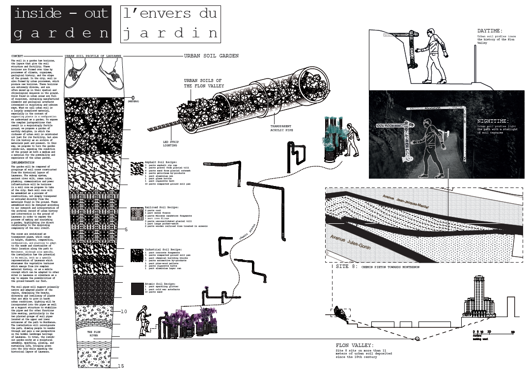
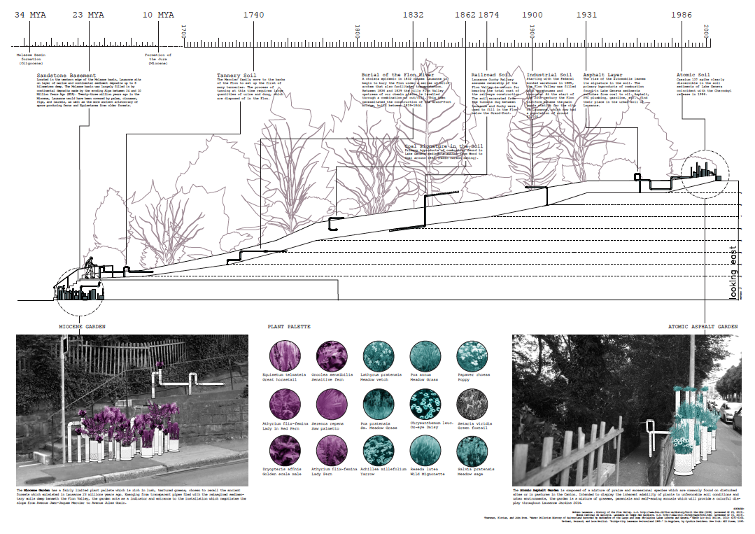
    The soil in a garden has horizons, the layers that give the soil structure and fertility. These horizons are formed over time by processes of climate, organisms, geological history, and the slope of the ground. In the city, soil is also formed by urban processes, which produce new horizons. These horizons are extremely diverse, and are often mixed up in their spatial and chronological sequence in the ground. Soils found in urban areas are full of surprises, containing manufactured elements and geological artifacts intermixed in surprising and unknown ways. What we call urban soil is a largely unexplored material, especially in the context of supporting plants in a configuration of what we understand as a garden. To expose the complex juxtapositions that result in a surprisingly fertile ground, we propose a garden of earthly delights, in which the richness of urban soil is celebrated not just for its fertility, but also for its history as an archive of materials past and present. In this way, we propose to turn the garden inside-out, exposing the condition of the ground as both a medium and a material for the possibility and experience of the urban garden. inside-out gardeninside-out gardenDrawing credit: Seth Denizen.

    The garden will be composed of groupings of soil cores constructed from the historical layers of Lausanne. The subway system, ancient river silt, roman ruins, plumbing, communication and power infrastructure will be horizons in a soil core we propose to take off the city. Each soil core will be assembled as a process of construction, not simply transposed or extruded directly from the materials found in the ground. These assemblies will be designed according to our research and interpretation of the archival record of urban history and intervention in the ground of Lausanne in order to expose the process of making and nourishing a garden, highlighting its direct relationship to the surprising complexity of the soil itself.

    The cores are envisioned as transparent pipes, which range in height, diameter, composition, configuration and planting to adapt to the needs and constraints of their location along the path to Montbenon. Although site specific, the installation has the potential to be mobile, both as a specific representation of Lausanne which showcases the vegetative textures which emerge from its complex material history, or as a mobile concept which can be adapted to other sites in Lausanne or elsewhere as a way to expose the possibilities of the ground beneath our feet. The soil pipes will support primarily native and adapted plants of the region, displaying the beauty, diversity and resiliency of plants that are able to grow in harsh urban conditions. Lighting will be incorporated into the pipes as well as a support structure to stabilize the pipes and for other functions like seating, particularly in the two planted groups of soil pipes located at the upper and lower entrances of the path to Montbenon. The installation will reinvigorate the path, drawing people to wander through and gain a new perspective on the hidden landscape heritage of Lausanne. In total, the inside-out garden works as a sculptural assembly, sparkling, glowing, and sustaining life, bringing green into the city while exposing the historical layers of Lausanne.